Posts

Showing posts with the label KAS

Island Development Agency
Image
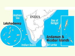
IDA was constituted in 2017 for holistic development of Indian islands, by ensuring no disturbance to Bio diversity and Ecological balance in islands. as these islands are strategically vital for Indian security and defense, can be assist Indian hegemony on Indian ocean. India has 615 islands/islets. Majority of them, around 572 islands/islets are located in the Bay of Bengal and remaining 43 islands/islets are located in the Arabian Sea. Apart from these, there are some coral islands in the Gulf of Mannar and Khambat regions and there are some offshore islands along the mouth of Ganga river. and provide great potential to tourism industry. IDA is chaired by Home Minister  of India. Members are- Cabinet secretary Home secretary Environment secretary tourism secretary tribal affair secretary till now under it 10 island are recognized 5 in Andman and Nicobar 5 in Lakshdeep

Drainage system of Jammu and Kashmir : explained

Image
Drainage system of Jammu Kashmir In Jammu and Kashmir, there is abundance of rivers and many rivulets, some are perennial while some are not. Due mountain and snowfall, here in jammu Kashmir, there are many rivers, which are fed by rain in summer and than by accumulated snows of high reaches. Just like Tawi, which have origin in Kailash Kund in upper ranges and the Jhelum which originated from the Panjal ranges or precisely the Verinag or Veth Vatru. These all rivers travel from east toward the south west and most of them end up in Pakistan and later reaches their main river or sea. What is drainage system? Drainage system in geomorphology simply means the river system. There are many pattern are formed by the rivers, rivulets and lakes, which are effected by the soft or hard rocks, which actually determine the course of the river. Drainage roughly means, under it the water is carried by the river or the rivulets toward the sea or some lake and in some case to the ponds. -Some f...